✨ New Arrivals Just Dropped!Explore
Collins Road Map of Ireland 2027 (Folded map)
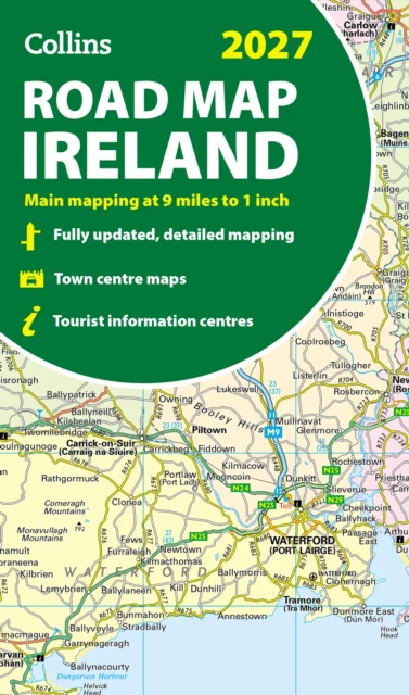
Explore Ireland with easy-to-read mapping from Collins. Full-colour map of Ireland at 9 miles to 1 inch (1:570,240), with clear, detailed road network and counties and new administrative areas shown in colour. This double-sided map covers the whole of Ireland, and is ideal for reference or route planning. This map of Ireland shows the road network in detail. It is ideal for business users, with colouring of local council areas, but it is also perfect for tourists as a route planning map. Main features include: Fully updatedNew administrative areas shown in colourClear, detailed road networkTown and city names, rivers, lakes, spot heights, railway lines and canals are clearly shownCity/town centre street plans of Belfast, Cork, Dublin, Dún Laoghaire, Galway, Limerick, Londonderry/Derry and Waterford showing places of interestFull index to place namesMileage chartCar ferry routesKey in English, French and German Area of coverageCovers the whole of the Republic of Ireland and Northern Ireland
Product Information
Product Information
Shipping & Returns
Shipping & Returns
Collins Road Map of Ireland 2027 (Folded map)
Collins Road Map of Ireland 2027 (Folded map)
Explore Ireland with easy-to-read mapping from Collins. Full-colour map of Ireland at 9 miles to 1 inch (1:570,240), with clear, detailed road network and counties and new administrative areas shown in colour. This double-sided map covers the whole of Ireland, and is ideal for reference or route planning. This map of Ireland shows the road network in detail. It is ideal for business users, with colouring of local council areas, but it is also perfect for tourists as a route planning map. Main features include: Fully updatedNew administrative areas shown in colourClear, detailed road networkTown and city names, rivers, lakes, spot heights, railway lines and canals are clearly shownCity/town centre street plans of Belfast, Cork, Dublin, Dún Laoghaire, Galway, Limerick, Londonderry/Derry and Waterford showing places of interestFull index to place namesMileage chartCar ferry routesKey in English, French and German Area of coverageCovers the whole of the Republic of Ireland and Northern Ireland
$10.78
Collins Road Map of Ireland 2027 (Folded map)—
$10.78
Product Information
Product Information
Shipping & Returns
Shipping & Returns
Description
Explore Ireland with easy-to-read mapping from Collins. Full-colour map of Ireland at 9 miles to 1 inch (1:570,240), with clear, detailed road network and counties and new administrative areas shown in colour. This double-sided map covers the whole of Ireland, and is ideal for reference or route planning. This map of Ireland shows the road network in detail. It is ideal for business users, with colouring of local council areas, but it is also perfect for tourists as a route planning map. Main features include: Fully updatedNew administrative areas shown in colourClear, detailed road networkTown and city names, rivers, lakes, spot heights, railway lines and canals are clearly shownCity/town centre street plans of Belfast, Cork, Dublin, Dún Laoghaire, Galway, Limerick, Londonderry/Derry and Waterford showing places of interestFull index to place namesMileage chartCar ferry routesKey in English, French and German Area of coverageCovers the whole of the Republic of Ireland and Northern Ireland